Beginning in November 02008, INSIGHT joined a team from Egypt’s Supreme Council for Antiquities (SCA) for an expedition in Egypt to study ancient quarries. The goal of the field work was to test current thinking about how Egyptian quarries worked by studying traces of ancient excavations and visualizing cumulative extractions of stone over time.
In granite quarries near Aswan, we used laser scanning to document the beds where largest obelisks were removed. In the massive quarries of Gebel Silsileh, which stretch along both sides of the Nile for many kilometers, we looked for interesting relationships between the Nile and its flanking work sites. Where chapels suggested votives were offered to the river, or where causeways once carried barges laden with worked stone when the Nile was in flood, we took note. By coordinating ground-penetrating sonar in the Nile with mapping of the surrounding quarries, we found objects of interest that SCA divers will explore in future seasons.
Starting in 02015, INSIGHT joined Dr. Maria Nilsson and Dr. John Ward of The Gebel es Silsileh Epigraphic Survey Project for their work on site. We created 3D documentation for their rediscovery of the “lost” temple of Kheny, as shown in the image sequence above. Our other projects on site have included photography and modeling of the speos at Gebel es Silsileh (see right), and numerous naoi on site, below.

Frédéric Wilner’s 2009 film Le secret des Pharaons bâtisseurs follows the expedition and funded much of the work. Sunken Treasures of the Nile is a one hour version of the film which was produced in 2010 by the National Geographic Channel. Greg Downing of xRez Studios joined INSIGHT for the field work and continues to work with INSIGHT on new output from this ongoing project. Carlos Velazquez of Epic Scan provided long-range laser scanning support, having previously worked with INSIGHT for Maya Skies field work.

Uncovering Stella M, an Unknown Stela of Ramesses II
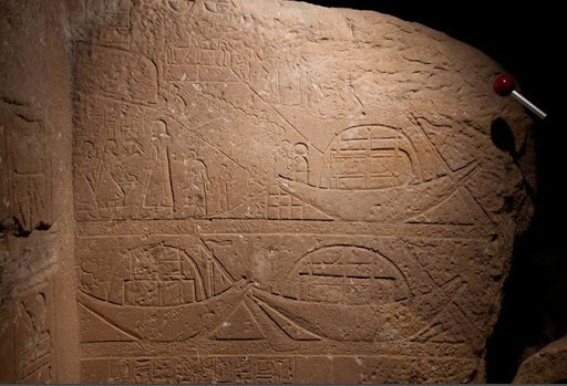
During the field work the team was fortunate to discover an unknown stela of Ramesses II on the eastern side of the Gebel es Silsileh, shown at right. The stela is a royal monument dedicated for Ramesses II at the beginning of his reign by one of his generals, named Hapy. Hapy is already known to have been active at Gebel es Silsileh, providing stones for Sethi I; the father of Ramesses II. The Stela itself was adorned by a vignette showing Ramesses II facing left and the theban triad encomprising Amun; Mut and Khonsu. The king was presented to the triad, by a god who has been later erased and who was followed by a goddess clearly identified as Nut; the godess of the sky. The erased god must have been Seth; a god linked to the deserts and thus the quarries. However either his presence would make him a local deity; giving then possible strength to the idea that Kom Ombo was dedicated to him during the pharaonic era. Or Seth and Nut could point to Ombos in Upper Egypt. However it remains difficult then to understand their presence so far from their cultic territory.
The most interesting feature of the stela lies in its right wing, pictured above. Its lower part shows general Hapy; kneeing in the posture of adoration in front of the royal name-rings set on a sema-taouy symbol. It clearly shows that Hapy was then the administrator in charge of the quarrying expedition and of the erection of the commemorative stela we are dealing with.
Above him, lies a scene that is quite unique in egyptian iconography: the representation of actual work in the quarry and of the loading of large monumental blocks. Two boats are moored in the first register above the figure of Hapy. The first one shows a prow decorated by the figure of the jackal god Wepwawet; the Opener of Roads, while the other prow which has been hacked out, may have represented the image of the god Seth. They are already loaded; each one with a big rectangular block of what we can assume is sandstone. Above them another boat can be seen tied to a quay. It is also loaded with a block that clearly describes a stela. This boat’s prow is adorned with the head of a solar falcon. Two men seem to be busy working around the quay, maybe securing the boat, but their action cannot be further precised.
To their left; stands General Hapy giving his orders to two scribes; one of them taking notes on a papyrus roll. Hapy seems to be just off the gangplank; and is followed by a smaller figure holding a stick that makes him a person in command; while another figure, apparently naked; seems to describe a child; strangely out of place in this quarrying context. Perhaps it is Hapy’s son; accompanying him in his inspection turn.
Above these officials; we finally see workmen occupied with the moving of another stela set on a sledge; and apparently to be moved along the ramp; leading from the quarry to the quay. A foreman is perched on the stela; giving orders for its displacement. A workmen is in front of the sledge,either wetting its path to make it smoother or on the contrary blocking it with a rock to slow down its motion. The band of hawlers is described as somewhat inform, in a simplified way, but rendered as active and varied in their positions; with one of them taking the lead and holding the end of the rope. Thus in just one register; the artist has described the two most important moments of the action with the stela at the top of the ramp; at the begining, and the stela already safely stached on board; thus showing us the happy result of all this energy. However the presence of the two large blocks set on the other boats; blocks that are clearly the basis of the stela; that the master feat of the expedition deals with two large stelae and their quadrangular basis.
Finally the top register describes the quarry and the action taking place into it. In the left corner can be seen a vertical structure that is difficult to define but may either describe the entrance to the worksite, a passage in the rock, or scaffoldings. To the right can be seen four stone-cutters working on a large block that is set up on another working area that seems to be linked to another ramp. In front of them comes an inspector who is holding a stick, maybe a cubit, and a level to verify the precision of their work. He is followed by another scribe taking notes. Above the group of stone cutters can be seen a round object and two corbs or rockers. Finally adding another anecdote to the description; a small group set aside to the upper right of the scene shows a workman tending to a wounded colleague who needs to have his left knee bandaged.
Though very limited in its size and scope, this representation is unique as it shows work in a quarry and is the first iconographic proof to the use of ramps to move large blocks. The representation of the moored loaded boats is also a welcome evidence. This rare description is even more interesting when poundered against its context that clearly enables us to understand the functioning of the nearby ramesside quarry, complete with its ramp and loading docks. As an official document; the stela also stresses the quarrying of large sandstone stelae for his and his father’s temple in Abydos and the Theban area.
Dr. Philippe Martinez, INSIGHT’s Lead Archaeologist, made the discovery of ‘Stella M’.
INSIGHT partner non-profit xRez Studios has published an interactive PTM view of Stella M.
Documentation at the Unfinished Obelisk Quarry
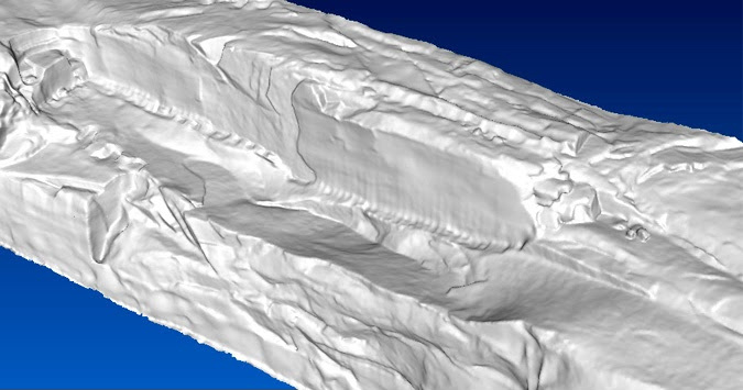
A key area of interest for our team during field work was the Unfinished Obelisk quarry near Aswan. To help understand the mechanics of the Unfinished Obelisk’s planned extraction, we worked backwards in time, establishing an excavation chronology for the stone quarried around it. Because the obelisk was not removed in antiquity, its partial extraction is highly didactic. In particular, the trenches around the Unfinished Obelisk are present elsewhere on the site (see the image below) in areas where large stone chunks were successfully extracted. By paying attention to the details of these trenches, we attempted to understand how they were produced and reconciled the extraction techniques proposed in existing publications against this documentation on site.
Large Scale Documentation of Quarries
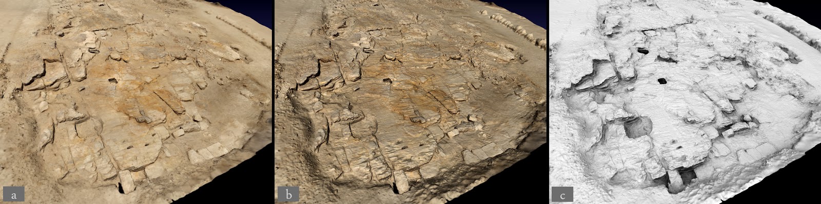
As part of our field work, we successfully gathered detailed 3D documentation for connected quarry regions spanning kilometers. The data we gathered for the large quarry groups around Gebel Silsileh is unique in Egypt. The enormous scale of such areas makes them subjects for conventional mapping, by default, rather than the sort of detailed laser scanning typically reserved for artifacts and structures.
During the field work phase, we were keenly focused on addressing this problem of high quality 3D documentation at larger scales. Happily, with our partners, we were able to make some meaningful progress. In order to simplify data acquisition in the field, we conducted trials using kite aerial photography (KAP) in combination with image-based modeling techniques, including Microsoft PhotoSynth. Comparing our results against traditional long-range laser scanning, we found that the accuracy and density of 3D information from KAP is sufficient to be very useful to archaeologists. Our team is continuing work in optimizing KAP for archaeology and hopes to offer a technical pipeline to the community in 2011.
While simplifying (and therefore reducing the cost) of data capture is an important topic, the most significant factors when applying 3D data to archaeology are decisions regarding the data pipeline. In our case, we focused on applying automatic (or semi-automatic) algorithms for transforming raw point data into clean, organized, decimated polygon meshes. The illustration below shows a point cloud derived from long-range laser scanning (top), a mesh derived using the Poisson surface reconstruction method (center), and a lighted model (bottom). Currently, significant human interaction is needed to align point clouds, cull noise points, convert to polygons, place color maps, and render images. Our ongoing research is focused on robust techniques to automate the previously enumerated steps.